Wednesday, July 9, 2014

Geography of Indonesia

Geography of Indonesia

Borneo is the 3rd largest island in the world and the original vegetation was mostly Borneo lowland rain forests although much of this has been cleared with wildlife retreating to the Borneo montane rain forests inland.
Geography of IndonesiaNusa Tenggara consists of two strings of islands stretching eastward from Bali toward Papua. The inner arc of Nusa Tenggara is a continuation of the chain of mountains and volcanoes extending from Sumatra through Java, Bali, and Flores, and trailing off in the volcanic Banda Islands, which along with the Kai Islands and the Tanimbar Islands and other small islands in the Banda Sea are typical examples of the Wallacea mixture of Asian and Australasian plant and animal life. The outer arc of Nusa Tenggara is a geological extension of the chain of islands west of Sumatra that includes Nias, Mentawai, and Enggano. This chain resurfaces in Nusa Tenggara in the ruggedly mountainous islands of Sumba and Timor.
Geography of IndonesiaThe Maluku Islands are geologically among the most complex of the Indonesian islands. They are located in the northeast sector of the archipelago, bounded by the Philippines to the north, Papua to the east, and Nusa Tenggara to the south. The largest of these islands include Halmahera, Seram and Buru, all of which rise steeply out of very deep seas and have unique Wallacea vegetation. This abrupt relief pattern from sea to high mountains means that there are very few level coastal plains. The islands of North Maluku are the original Spice Islands, a distinct rainforest ecoregion.
Lying along the equator, Indonesia's climate tends to be relatively even year-round. The country experiences two seasonsâ€"a wet season and a dry seasonâ€"with no extremes of summer or winter. For most of Indonesia, the wet season falls between October and April with the dry season between May and September. Some regions, such as Kalimantan and Sumatra, experience only slight differences in rainfall and temperature between the seasons, whereas others, such as Nusa Tenggara, experience far more pronounced differences with droughts in the dry season, and floods in the wet. Rainfall in Indonesia is plentiful, particularly in west Sumatra, northwest Kalimantan, west Java, and western New Guinea.
For centuries, the geographical resources of the Indonesian archipelago have been exploited in ways that fall into consistent social and historical patterns. One cultural pattern consists of the formerly Indianized, rice-growing peasants in the valleys and plains of Sumatra, Java, and Bali; another cultural complex is composed of the largely Islamic coastal commercial sector; a third, more marginal sector consists of the upland forest farming communities which exist by means of subsistence swidden agriculture. To some degree, these patterns can be linked to the geographical resources themselves, with abundant shoreline, generally calm seas, and steady winds favoring the use of sailing vessels, and fertile valleys and plainsâ€"at least in the Greater Sunda Islandsâ€"permitting irrigated rice farming. The heavily forested, mountainous interior hinders overland communication by road or river, but fosters slash-and-burn agriculture.
Indonesia's high population and rapid industrialisation present serious environmental issues, which are often given a lower priority due to high poverty levels and weak, under-resourced governance. Issues include large-scale deforestation and related wildfires causing heavy smog over parts of western Indonesia, Malaysia and Singapore; over-exploitation of marine resources; and environmental problems associated with rapid urbanization and economic development, including air pollution, traffic congestion, garbage management, and reliable water and waste water services. Deforestation and the destruction of peatlands make Indonesia the world's 3rd largest emitter of greenhouse gases. Habitat destruction threatens the survival of indigenous and endemic species, including 140 species of mammals identified by the World Conservation Union (IUCN) as threatened, and 15 identified as critically endangered, including the Sumatran Orangutan.
In 1970, 15% of Indonesians lived in cities compared to over 30% today, and this increases pressure on the urban environment. Industrial pollution is increasing, particularly in Java, and the increasing affluence of the growing middle class drives a rapid increase in the number of motor vehicles and associated emissions. Garbage and waste water services are being placed under increasing pressure. Reliance on septic systems or effluent disposal in open canals and river systems remains the norm, and is a major polluter of water resources. Very few Indonesians have access to safe drinking water and must boil it before use.

Related Sites for Geography of Indonesia

Tuesday, July 8, 2014

Arema FC U-21

Arema FC U-21

Arema FC U-21 is an Indonesian football team based in Malang, East Java. Their 1st team is one of the most supported and successful football clubs in Indonesia. They currently play at the Indonesian top league, the Indonesia Super League U-21.
Arema is born out of the pride of the citizens of Malang. With the desire to establish themselves as a famous and a high nobility society, the people of Malang participated in all kinds of activities (which includes boxing, rock music and athleticism) to help establish the Malang as one of the famous societies in Indonesia.
Arema FC U-21Arema FC U-21Arema is also the name of an Indonesian/Javanese legend, Kebo Arema who is thought to originate from Malang. Due to this fact, "Arema" became a relevant name to be used for the culture and identity of Malang.
Arema plays up to 40,000 capacity's Kanjuruhan Stadium in Malang. In the past they played at the Gajayana Stadium, Malang for AFC Champions League matches.
The club's supporters who call themselves as the Aremania are considered to be one of the most fanatic supporters among all of the Indonesian football clubs supporters. Apart from their home base city, the club fans are spread all around the country. In 2000 & 2006, the Aremania has been awarded as The Best Indonesian Football Supporters by Football Association of Indonesia.
Note: Flags indicate national team as has been defined under FIFA eligibility rules. Players may hold more than one non-FIFA nationality.

Related Sites for Arema FC U-21

Friday, July 4, 2014

Rudy Hartono : a former Indonesian badminton star


Rudy Hartono

Rudy Hartono Kurniawan, born August 18, 1949) is a former Indonesian badminton star who won the men's singles title at the World Championship in 1980, and the prestigious All-England Championship trophy eight times, seven times consecutively (1968â€"1974), in the 1960s and 1970s. He is one of the most famous players in the history of the sport and is considered to be one of the greatest badminton players of all time. His sister is also a former world-level badminton player, Utami Dewi Kinard.
Rudy HartonoDuring his prime years Hartono won men's singles in most of the international tournaments that he entered. He also played on six consecutive Indonesian Thomas Cup teams between 1967 and 1982, the 1st of these when he was only seventeen, helping Indonesia to win four consecutive world team championships (1970, 1973, 1976, 1979) in what was then a triennial event. His game was characterized by great power, accuracy, agility, mobility, aggressiveness, and coolness under pressure. In 1997 he was among the 1st group of players inducted into the World Badminton Hall of Fame.
Rudy HartonoHartono competed in badminton at the 1972 Summer Olympics, where badminton was one of two demonstration sports. It was the 1st time that the sport was part of the Olympic program, and it would become an official Olympic sport 20 years later at the 1992 Summer Olympics.
He won the men's singles event, after beating Jamie Paulson of Canada in the 1st round, Sture Johnsson of Sweden in the semifinals, and Svend Pri of Denmark in the final 15â€"6, 15â€"1.

Related Sites for Rudy Hartono

Post-independence Indonesia

Post-independence Indonesia

The history of Indonesia has been shaped by its geographic position, its natural resources, a series of human migrations and contacts, wars and conquests, as well as by trade, economics and politics. Indonesia is an archipelagic country of 17,508 islands stretching along the equator in South East Asia. The country's strategic sea-lane position fostered inter-island and international trade; trade has since fundamentally shaped Indonesian history. The area of Indonesia is populated by peoples of various migrations, creating a diversity of cultures, ethnicities, and languages. The archipelago's landforms and climate significantly influenced agriculture and trade, and the formation of states. The boundaries of the state of Indonesia represent the twentieth century borders of the Dutch East Indies.
Post-independence Indonesia
Europeans arrived in Indonesia from the 16th century seeking to monopolise the sources of valuable nutmeg, cloves, and cubeb pepper in Maluku. In 1602 the Dutch established the Dutch East India Company and became the dominant European power by 1610. Following bankruptcy, the VOC was formally dissolved in 1800, and the government of the Netherlands established the Dutch East Indies under government control. By the early 20th century, Dutch dominance extended to the current boundaries. The Japanese invasion and subsequent occupation in 1942-45 during WWII ended Dutch rule, and encouraged the previously suppressed Indonesian independence movement. Two days after the surrender of Japan in August 1945, nationalist leader, Sukarno, declared independence and became president. The Netherlands tried to reestablish its rule, but a bitter armed and diplomatic struggle ended in December 1949, when in the face of international pressure, the Dutch formally recognised Indonesian independence.
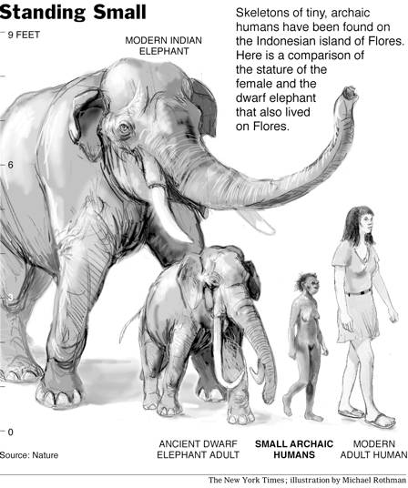
In 2003, on the island of Flores, fossils of a new small hominid dated between 74,000 and 13,000 years old and named "Flores Man" were discovered much to the surprise of the scientific community. This 3 foot tall hominid is thought to be a species descended from Homo Erectus and reduced in size over thousands of years by a well known process called island dwarfism. Flores Man seems to have shared the island with modern Homo sapiens until only 12,000 years ago, when they became extinct. In 2010 stone tools were discovered on Flores dating from 1 million years ago, which is the oldest evidence anywhere in the world that early man had the technology to make sea crossings at this very early time.
The archipelago was formed during the thaw after the latest ice age. Early humans to travelled by sea and spread from mainland Asia eastward to New Guinea and Australia. Homo sapiens reached the region by around 45,000 years ago. In 2011 evidence was uncovered in neighbouring East Timor, showing that 42,000 years ago these early settlers had high-level maritime skills, and by implication the technology needed to make ocean crossings to reach Australia and other islands, as they were catching and consuming large numbers of big deep sea fish such as tuna.
Ideal agricultural conditions, and the mastering of wet-field rice cultivation as early as the 8th century BCE, allowed villages, towns, and small kingdoms to flourish by the 1st century CE. These kingdoms evolved with their own ethnic and tribal religions. Java's hot and even temperature, abundant rain and volcanic soil, was perfect for wet rice cultivation. Such agriculture required a well organised society in contrast to dry-field rice which is a much simpler form of cultivation that doesn't require an elaborate social structure to support it.
References to the Dvipantara or Jawa Dwipa Hindu kingdom in Java and Sumatra appear in Sanskrit writings from 200 BCE. The earliest archeological relic discovered in Indonesia is from the Ujung Kulon National Park, West Java, where an early Hindu statue of Ganesha from the 1st century CE was found on the summit of Mount Raksa in Panaitan Island. There is also archeological evidence of a kingdom in Sunda territory in West Java dating from the 2nd century, and according to Dr Tony Djubiantono, the head of Bandung Archeology Agency, Jiwa Temple in Batujaya, Karawang, West Java was also built around this time.
A number of Hindu and Buddhist states flourished and then declined across Indonesia. By the time of the European Renaissance, Java and Sumatra had already seen over a millennium of civilization and two major empires. One such early kingdom was Tarumanagara, which flourished between 358 and 669 CE. Located in West Java close to modern-day Jakarta, its 5th-century king, Purnawarman, established the earliest known inscriptions in Java, the Ciaruteun inscription located near Bogor. On this monument, King Purnavarman inscribed his name and made an imprint of his footprints, as well as his elephant's footprints. The accompanying inscription reads, "Here are the footprints of King Purnavarman, the heroic conqueror of the world". This inscription is in Sanskrit and is still clear after 1500 years. Purnawarman apparently built a canal that changed the course of the Cakung River, and drained a coastal area for agriculture and settlement. In his stone inscriptions, Purnawarman associated himself with Vishnu, and Brahmins ritually secured the hydraulic project.
Three rough plinths dating from the beginning of the 4th century are found in Kutai, East Kalimantan, near Mahakam River. The plinths bear an inscription in the Pallava script of India reading "A gift to the Brahmin priests".
The political history of Indonesian archipelago during the 7th to 11th centuries was dominated by Srivijaya based in Sumatra, also Sailendra that dominated central Java and constructed Borobudur, the largest Buddhist monument in the world. The history of the 14th and 15th centuries isn't well known due to scarcity of evidence. Two major states dominated this period; Majapahit in East Java, the greatest of the pre-Islamic Indonesian states, and Malacca on the west coast of the Malay Peninsula, arguably the greatest of the Muslim trading empires.
Medang or previously known as Mataram was an Indianized kingdom based in Central Java around modern-day Yogyakarta between the 8th and 10th centuries. The center of the kingdom was moved from central Java to east Java by Mpu Sindok. An eruption of Mount Merapi volcano or a power struggle may have caused the move.
The 1st king of Mataram was Sri Sanjaya and left inscriptions in stone. The monumental Hindu temple of Prambanan in the vicinity of Yogyakarta was built by Daksa. Dharmawangsa ordered the translation of the Mahabharata into Old Javanese in 996.
The kingdom collapsed into chaos at the end of Dharmawangsa's reign under military pressure from Srivijaya. One of the last major kings of Mataram was Airlangga who reigned from 1016 until 1049. Airlangga was a son of Udayana of Bali and a relative of Dharmawangsa re-established the kingdom including Bali under the name of Kahuripan.
Srivijaya was centred in the coastal trading centre of present day Palembang. Srivijaya wasn't a "state" in the modern sense with defined boundaries and a centralized government to which the citizens own allegiance. Rather Srivijaya was a confederacy form of society centered on a royal heartland. It was a thalassocracy and didn't extend its influence far beyond the coastal areas of the islands of Southeast Asia. Trade was the driving force of Srivijaya just as it is for most societies throughout history. The Srivijayan navy controlled the trade that made its way through the Strait of Malacca.
By the 7th century, the harbors of various vassal states of Srivijaya lined both coasts of the Straits of Melaka. Around this time, Srivijaya had established suzerainty over large areas of Sumatra, western Java, and much of the Malay Peninsula. Dominating the Malacca and Sunda straits, the empire controlled both the Spice Route traffic and local trade. It remained a formidable sea power until the 13th century. This spread the ethnic Malay culture throughout Sumatra, the Malay Peninsula, and western Borneo. A stronghold of Vajrayana Buddhism, Srivijaya attracted pilgrims and scholars from other parts of Asia.
A series of Chola raids in the 11th century weakened the Srivijayan hegemony and enabled the formation of regional kingdoms based, like Kediri, on intensive agriculture rather than coastal and long distance trade. Srivijayan influence waned by the 11th century. The island was in frequent conflict with the Javanese kingdoms, 1st Singhasari and then Majapahit. Islam eventually made its way to the Aceh region of Sumatra, spreading its influence through contacts with Arabs and Indian traders. By the late 13th century, the kingdom of Pasai in northern Sumatra converted to Islam. At that time Srivijaya was briefly a tributary of the Khmer empire and later the Sukhothai kingdom. The last inscription dates to 1374, where a crown prince, Ananggavarman, is mentioned. Srivijaya ceased to exist by 1414, when Parameswara, the kingdom's last prince, converted to Islam and founded the Sultanate of Malacca on the Malay peninsula.
Despite a lack of historical evidence, it is known that Majapahit was the most dominant of Indonesia's pre-Islamic states. The Hindu Majapahit kingdom was founded in eastern Java in the late 13th century, and under Gajah Mada it experienced what is often referred to as a "Golden Age" in Indonesian history, when its influence extended to much of southern Malay Peninsula, Borneo, Sumatra, and Bali from about 1293 to around 1500.
The founder of the Majapahit Empire, Kertarajasa, was the son-in-law of the ruler of the Singhasari kingdom, also based in Java. After Singhasari drove Srivijaya out of Java in 1290, the rising power of Singhasari came to the attention of Kublai Khan in China and he sent emissaries demanding tribute. Kertanagara, ruler of the Singhasari kingdom, refused to pay tribute and the Khan sent a punitive expedition which arrived off the coast of Java in 1293. By that time, a rebel from Kediri, Jayakatwang, had killed Kertanagara. The Majapahit founder allied himself with the Mongols against Jayakatwang and, once the Singhasari kingdom was destroyed, turned and forced his Mongol allies to withdraw in confusion.
The earliest accounts of the Indonesian archipelago date from the Abbasid Caliphate, according to those early accounts the Indonesian archipelago were famous among early muslim sailors mainly due to its abundance of precious spice trade commodities such as nutmeg, cloves, galangal and many other spices.
Although Muslim traders 1st traveled through South East Asia early in the Islamic era, the spread of Islam among the inhabitants of the Indonesian archipelago dates to the 13th century in northern Sumatra. Although it is known that the spread of Islam began in the west of the archipelago, the fragmentary evidence does not suggest a rolling wave of conversion through adjacent areas; rather, it suggests the process was complicated and slow. The spread of Islam was driven by increasing trade links outside of the archipelago; in general, traders and the royalty of major kingdoms were the 1st to adopt the new religion.
Other Indonesian areas gradually adopted Islam, making it the dominant religion in Java and Sumatra by the end of the 16th century. For the most part, Islam overlaid and mixed with existing cultural and religious influences, which shaped the predominant form of Islam in Indonesia, particularly in Java. Only Bali retained a Hindu majority. In the eastern archipelago, both Christian and Islamic missionaries were active in the 16th and 17th centuries, and, currently, there are large communities of both religions on these islands.
The Sultanate of Mataram was the 3rd Sultanate in Java, after the Sultanate of Demak Bintoro and the Sultanate of Pajang.
According to Javanese records, Kyai Gedhe Pamanahan became the ruler of the Mataram area in the 1570s with the support of the kingdom of Pajang to the east, near the current site of Surakarta. Pamanahan was often referred to as Kyai Gedhe Mataram after his ascension.
Pamanahan's son, Panembahan Senapati Ingalaga, replaced his father on the throne around 1584. Under Senapati the kingdom grew substantially through regular military campaigns against Mataram's neighbors. Shortly after his accession, for example, he conquered his father's patrons in Pajang.
The reign of Panembahan Seda ing Krapyak, the son of Senapati, was dominated by further warfare, especially against powerful Surabaya, already a major center in East Java. The 1st contact between Mataram and the Dutch East India Company (VOC) occurred under Krapyak. Dutch activities at the time were limited to trading from limited coastal settlements, so their interactions with the inland Mataram kingdom were limited, although they did form an alliance against Surabaya in 1613. Krapyak died that year.

Related Sites for Post-independence Indonesia

Pre-colonial Indonesia


Pre-colonial Indonesia

Pre-colonial IndonesiaThe history of Indonesia has been shaped by its geographic position, its natural resources, a series of human migrations and contacts, wars and conquests, as well as by trade, economics and politics. Indonesia is an archipelagic country of 17,508 islands stretching along the equator in South East Asia. The country's strategic sea-lane position fostered inter-island and international trade; trade has since fundamentally shaped Indonesian history. The area of Indonesia is populated by peoples of various migrations, creating a diversity of cultures, ethnicities, and languages. The archipelago's landforms and climate significantly influenced agriculture and trade, and the formation of states. The boundaries of the state of Indonesia represent the twentieth century borders of the Dutch East Indies.
Pre-colonial IndonesiaEuropeans arrived in Indonesia from the 16th century seeking to monopolise the sources of valuable nutmeg, cloves, and cubeb pepper in Maluku. In 1602 the Dutch established the Dutch East India Company and became the dominant European power by 1610. Following bankruptcy, the VOC was formally dissolved in 1800, and the government of the Netherlands established the Dutch East Indies under government control. By the early 20th century, Dutch dominance extended to the current boundaries. The Japanese invasion and subsequent occupation in 1942-45 during WWII ended Dutch rule, and encouraged the previously suppressed Indonesian independence movement. Two days after the surrender of Japan in August 1945, nationalist leader, Sukarno, declared independence and became president. The Netherlands tried to reestablish its rule, but a bitter armed and diplomatic struggle ended in December 1949, when in the face of international pressure, the Dutch formally recognised Indonesian independence.
In 2003, on the island of Flores, fossils of a new small hominid dated between 74,000 and 13,000 years old and named "Flores Man" were discovered much to the surprise of the scientific community. This 3 foot tall hominid is thought to be a species descended from Homo Erectus and reduced in size over thousands of years by a well known process called island dwarfism. Flores Man seems to have shared the island with modern Homo sapiens until only 12,000 years ago, when they became extinct. In 2010 stone tools were discovered on Flores dating from 1 million years ago, which is the oldest evidence anywhere in the world that early man had the technology to make sea crossings at this very early time.
The archipelago was formed during the thaw after the latest ice age. Early humans to travelled by sea and spread from mainland Asia eastward to New Guinea and Australia. Homo sapiens reached the region by around 45,000 years ago. In 2011 evidence was uncovered in neighbouring East Timor, showing that 42,000 years ago these early settlers had high-level maritime skills, and by implication the technology needed to make ocean crossings to reach Australia and other islands, as they were catching and consuming large numbers of big deep sea fish such as tuna.
Ideal agricultural conditions, and the mastering of wet-field rice cultivation as early as the 8th century BCE, allowed villages, towns, and small kingdoms to flourish by the 1st century CE. These kingdoms evolved with their own ethnic and tribal religions. Java's hot and even temperature, abundant rain and volcanic soil, was perfect for wet rice cultivation. Such agriculture required a well organised society in contrast to dry-field rice which is a much simpler form of cultivation that doesn't require an elaborate social structure to support it.
References to the Dvipantara or Jawa Dwipa Hindu kingdom in Java and Sumatra appear in Sanskrit writings from 200 BCE. The earliest archeological relic discovered in Indonesia is from the Ujung Kulon National Park, West Java, where an early Hindu statue of Ganesha from the 1st century CE was found on the summit of Mount Raksa in Panaitan Island. There is also archeological evidence of a kingdom in Sunda territory in West Java dating from the 2nd century, and according to Dr Tony Djubiantono, the head of Bandung Archeology Agency, Jiwa Temple in Batujaya, Karawang, West Java was also built around this time.
A number of Hindu and Buddhist states flourished and then declined across Indonesia. By the time of the European Renaissance, Java and Sumatra had already seen over a millennium of civilization and two major empires. One such early kingdom was Tarumanagara, which flourished between 358 and 669 CE. Located in West Java close to modern-day Jakarta, its 5th-century king, Purnawarman, established the earliest known inscriptions in Java, the Ciaruteun inscription located near Bogor. On this monument, King Purnavarman inscribed his name and made an imprint of his footprints, as well as his elephant's footprints. The accompanying inscription reads, "Here are the footprints of King Purnavarman, the heroic conqueror of the world". This inscription is in Sanskrit and is still clear after 1500 years. Purnawarman apparently built a canal that changed the course of the Cakung River, and drained a coastal area for agriculture and settlement. In his stone inscriptions, Purnawarman associated himself with Vishnu, and Brahmins ritually secured the hydraulic project.
Three rough plinths dating from the beginning of the 4th century are found in Kutai, East Kalimantan, near Mahakam River. The plinths bear an inscription in the Pallava script of India reading "A gift to the Brahmin priests".
The political history of Indonesian archipelago during the 7th to 11th centuries was dominated by Srivijaya based in Sumatra, also Sailendra that dominated central Java and constructed Borobudur, the largest Buddhist monument in the world. The history of the 14th and 15th centuries isn't well known due to scarcity of evidence. Two major states dominated this period; Majapahit in East Java, the greatest of the pre-Islamic Indonesian states, and Malacca on the west coast of the Malay Peninsula, arguably the greatest of the Muslim trading empires.
Medang or previously known as Mataram was an Indianized kingdom based in Central Java around modern-day Yogyakarta between the 8th and 10th centuries. The center of the kingdom was moved from central Java to east Java by Mpu Sindok. An eruption of Mount Merapi volcano or a power struggle may have caused the move.
The 1st king of Mataram was Sri Sanjaya and left inscriptions in stone. The monumental Hindu temple of Prambanan in the vicinity of Yogyakarta was built by Daksa. Dharmawangsa ordered the translation of the Mahabharata into Old Javanese in 996.
The kingdom collapsed into chaos at the end of Dharmawangsa's reign under military pressure from Srivijaya. One of the last major kings of Mataram was Airlangga who reigned from 1016 until 1049. Airlangga was a son of Udayana of Bali and a relative of Dharmawangsa re-established the kingdom including Bali under the name of Kahuripan.
Srivijaya was centred in the coastal trading centre of present day Palembang. Srivijaya wasn't a "state" in the modern sense with defined boundaries and a centralized government to which the citizens own allegiance. Rather Srivijaya was a confederacy form of society centered on a royal heartland. It was a thalassocracy and didn't extend its influence far beyond the coastal areas of the islands of Southeast Asia. Trade was the driving force of Srivijaya just as it is for most societies throughout history. The Srivijayan navy controlled the trade that made its way through the Strait of Malacca.
By the 7th century, the harbors of various vassal states of Srivijaya lined both coasts of the Straits of Melaka. Around this time, Srivijaya had established suzerainty over large areas of Sumatra, western Java, and much of the Malay Peninsula. Dominating the Malacca and Sunda straits, the empire controlled both the Spice Route traffic and local trade. It remained a formidable sea power until the 13th century. This spread the ethnic Malay culture throughout Sumatra, the Malay Peninsula, and western Borneo. A stronghold of Vajrayana Buddhism, Srivijaya attracted pilgrims and scholars from other parts of Asia.
A series of Chola raids in the 11th century weakened the Srivijayan hegemony and enabled the formation of regional kingdoms based, like Kediri, on intensive agriculture rather than coastal and long distance trade. Srivijayan influence waned by the 11th century. The island was in frequent conflict with the Javanese kingdoms, 1st Singhasari and then Majapahit. Islam eventually made its way to the Aceh region of Sumatra, spreading its influence through contacts with Arabs and Indian traders. By the late 13th century, the kingdom of Pasai in northern Sumatra converted to Islam. At that time Srivijaya was briefly a tributary of the Khmer empire and later the Sukhothai kingdom. The last inscription dates to 1374, where a crown prince, Ananggavarman, is mentioned. Srivijaya ceased to exist by 1414, when Parameswara, the kingdom's last prince, converted to Islam and founded the Sultanate of Malacca on the Malay peninsula.
Despite a lack of historical evidence, it is known that Majapahit was the most dominant of Indonesia's pre-Islamic states. The Hindu Majapahit kingdom was founded in eastern Java in the late 13th century, and under Gajah Mada it experienced what is often referred to as a "Golden Age" in Indonesian history, when its influence extended to much of southern Malay Peninsula, Borneo, Sumatra, and Bali from about 1293 to around 1500.
The founder of the Majapahit Empire, Kertarajasa, was the son-in-law of the ruler of the Singhasari kingdom, also based in Java. After Singhasari drove Srivijaya out of Java in 1290, the rising power of Singhasari came to the attention of Kublai Khan in China and he sent emissaries demanding tribute. Kertanagara, ruler of the Singhasari kingdom, refused to pay tribute and the Khan sent a punitive expedition which arrived off the coast of Java in 1293. By that time, a rebel from Kediri, Jayakatwang, had killed Kertanagara. The Majapahit founder allied himself with the Mongols against Jayakatwang and, once the Singhasari kingdom was destroyed, turned and forced his Mongol allies to withdraw in confusion.
The earliest accounts of the Indonesian archipelago date from the Abbasid Caliphate, according to those early accounts the Indonesian archipelago were famous among early muslim sailors mainly due to its abundance of precious spice trade commodities such as nutmeg, cloves, galangal and many other spices.
Although Muslim traders 1st traveled through South East Asia early in the Islamic era, the spread of Islam among the inhabitants of the Indonesian archipelago dates to the 13th century in northern Sumatra. Although it is known that the spread of Islam began in the west of the archipelago, the fragmentary evidence does not suggest a rolling wave of conversion through adjacent areas; rather, it suggests the process was complicated and slow. The spread of Islam was driven by increasing trade links outside of the archipelago; in general, traders and the royalty of major kingdoms were the 1st to adopt the new religion.
Other Indonesian areas gradually adopted Islam, making it the dominant religion in Java and Sumatra by the end of the 16th century. For the most part, Islam overlaid and mixed with existing cultural and religious influences, which shaped the predominant form of Islam in Indonesia, particularly in Java. Only Bali retained a Hindu majority. In the eastern archipelago, both Christian and Islamic missionaries were active in the 16th and 17th centuries, and, currently, there are large communities of both religions on these islands.
The Sultanate of Mataram was the 3rd Sultanate in Java, after the Sultanate of Demak Bintoro and the Sultanate of Pajang.
According to Javanese records, Kyai Gedhe Pamanahan became the ruler of the Mataram area in the 1570s with the support of the kingdom of Pajang to the east, near the current site of Surakarta. Pamanahan was often referred to as Kyai Gedhe Mataram after his ascension.
Pamanahan's son, Panembahan Senapati Ingalaga, replaced his father on the throne around 1584. Under Senapati the kingdom grew substantially through regular military campaigns against Mataram's neighbors. Shortly after his accession, for example, he conquered his father's patrons in Pajang.
The reign of Panembahan Seda ing Krapyak, the son of Senapati, was dominated by further warfare, especially against powerful Surabaya, already a major center in East Java. The 1st contact between Mataram and the Dutch East India Company (VOC) occurred under Krapyak. Dutch activities at the time were limited to trading from limited coastal settlements, so their interactions with the inland Mataram kingdom were limited, although they did form an alliance against Surabaya in 1613. Krapyak died that year.

Related Sites for Pre-colonial Indonesia

Java man

Java man

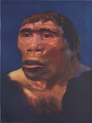
Java Man is the name given to fossils discovered in 1891 at Trinil - Ngawi Regency on the banks of the Solo River in East Java, Indonesia, one of the 1st known specimens of Homo erectus. Its discoverer, Eugxne Dubois, gave it the scientific name Pithecanthropus erectus, a name derived from Greek and Latin roots meaning upright ape-man.
Java manIn 1887, Eugxne Dubois began to excavate caves in Southeast Asia while working as a military surgeon. Dubois hoped to learn more about human evolution and to discover an ancestor of modern man. With this goal in mind he traveled to Sumatra, but after he failed to find the fossils he was looking for on the island he moved onto Java in 1890. Assisted by convict laborers and two army sergeants, Dubois began searching along the Solo River at Trinil in August of 1891.
Java manThe new date of the Mojokerto child, Dr. Swisher's group [of the Institute of Human Origins in Berkeley] has determined, is about 1.81 million years, and the Sangiran fossils are about 1.66 million years old.
Until older human remains were discovered in the Great Rift Valley in Kenya, Dubois' and Koenigswald's discoveries were the oldest hominid remains ever found. Some scientists of the day suggested Dubois' Java Man as a potential intermediate form between modern humans and the common ancestor we share with the other great apes. The current consensus of anthropologists is that the direct ancestors of modern humans were African populations of Homo erectus, rather than the Asian populations exemplified by Java Man and Peking Man.

Related Sites for Java man

Flores Man

Flores Man

Doubts that the remains constitute a new species were soon voiced by the Indonesian anthropologist Teuku Jacob, who suggested that the skull of LB1 was a microcephalic modern human. Two studies by paleoneurologist Dean Falk and her colleagues rejected this possibility. Falk et al. (2005) has been rejected by Martin et al. (2006) and Jacob et al. (2006), but defended by Morwood (2005) and Argue, Donlon et al. (2006).
Critics of the claim for species status continue to believe that these individuals are Homo sapiens possessing pathologies of anatomy and physiology. A 2nd hypothesis in this category is that the individuals were born without a functioning thyroid, resulting in a type of endemic cretinism.
Flores Man
Sophisticated stone implements of a size considered appropriate to the 3-foot-tall human are also widely present in the cave. The implements are at horizons from 95,000 to 13,000 years ago and are associated with an elephant of the extinct genus Stegodon (which was widespread throughout Asia during the Quaternary), presumably the prey of LB1. They also shared the island with giant rats, Komodo dragons, and even larger species of lizards. Homo sapiens reached the region by around 45,000 years ago.
Flores ManHomo floresiensis was unveiled on 28 October 2004, and was swiftly nicknamed the "Hobbit", after the fictional race popularized in J. R. R. Tolkien's book The Hobbit, and a proposed scientific name for the species was Homo hobbitus. It was initially placed in its own genus, Sundanthropus floresianus, but reviewers of the article felt that the cranium, despite its size, belonged in the genus Homo.
The 1st set of remains to have been found, LB1, was chosen as the type specimen for the proposed species. LB1 is a fairly complete skeleton, including a nearly complete cranium, determined to be that of a 30-year-old female. LB1 has been nicknamed the Little Lady of Flores or "Flo".
An indicator of intelligence is the size of Brodmann's area 10, the dorsomedial prefrontal cortex, an area of the brain associated with higher cognition. LB1's region 10 is about the same size as that of modern humans, despite the much smaller overall size of the brain.
Additional features used to argue that the finds come from a population of previously unidentified hominids include the absence of a chin, the relatively low twist of the arm bones, and the thickness of the leg bones. The presence of each of these features has been confirmed by independent investigators but their significance has been disputed.
Tocheri et al. examined three carpal bones believed to belong to LB1. The shapes of these bones were claimed to differ significantly from the bones of the modern human wrist and to resemble the wrist of great African apes or Australopithecus.
In early December 2004, Indonesian paleoanthropologist Teuku Jacob removed most of the remains from their repository, Jakarta's National Research Centre of Archaeology, with the permission of only one of the project team's directors and kept them for three months. Some scientists expressed the fear that important scientific evidence would be sequestered by a small group of scientists who neither allowed access by other scientists nor published their own research. Jacob returned the remains on February 23, 2005 with portions severely damaged and missing two leg bones to the worldwide consternation of his peers.
Reports noted the condition of the returned remains; "[including] long, deep cuts marking the lower edge of the Hobbit's jaw on both sides, said to be caused by a knife used to cut away the rubber mould"; "the chin of a 2nd Hobbit jaw was snapped off and glued back together. Whoever was responsible misaligned the pieces and put them at an incorrect angle"; and, "The pelvis was smashed, destroying details that reveal body shape, gait and evolutionary history" and causing the discovery team leader Morwood to remark "It's sickening, Jacob was greedy and acted totally irresponsibly".
Jacob, however, denied any wrongdoing. He stated that the damages occurred during transport from Yogyakarta back to Jakarta despite the physical evidence to the contrary that the jawbone had been broken while making a mould of bones.
In 2005 Indonesian officials forbade access to the cave. Some news media, such as the BBC, expressed the opinion that the reason for the restriction was to protect Jacob, who was considered "Indonesia's king of palaeoanthropology", from being proven to be wrong. Scientists were allowed to return to the cave in 2007 shortly after the death of Jacob.
In response, Weber et al. conducted a survey the same year comparing the computer model of LB1's skull with a sample of microcephalic human skulls, concluding that the skull size of LB1 falls in the middle of the size range of the human samples and isn't inconsistent with microcephaly. Next to dispute the finding of Falk et al. were Martin et al. (2006), who objected to the failure to compare the model of LB1's skull with a typical example of adult microcephaly. Martin and his coauthors concluded that the skull was probably microcephalic, arguing that the brain is far too small to be a separate dwarf species; if it were, the 400-cubic-centimeter brain would indicate a creature only one foot in height, one-third the size of the discovered skeleton. Shortly thereafter, a group of scientists from Indonesia, Australia, and the United States came to the same conclusion by examining bone and skull structure (Jacob (2006)).
In 2013, a comparison of the LB1 endocast to a set of 100 normocephalic and 17 microcephalic endocasts by Vannucci, Baron and Holloway showed that there is a wide variation in microcephalic brain shape ratios and that in these ratios the group as such isn't clearly distinct from normocephalics. The LB1 brain shape nevertheless aligns slightly better with the microcephalic sample, with the shape at the extreme edge of the normocephalic group.
Affected people, who were born without a functioning thyroid, have both small bodies and reduced brain size but their mental retardation and motor disability isn't as severe as with neurological endemic cretins. According to the authors of the study, the critical environment could have been present on Flores approximately 18,000 years ago, the period to which the LB fossils are dated. They wrote that various features found on the fossils, such as enlarged pituitary fossa, unusually straight and untwisted tops of the upper arm bone and relatively thick limbs, are signs of this diagnosis. The double rooted lower premolar and primitive wrist morphology can be explained in this way as well. The oral stories about strange human-like creatures may also be a record of cretinism.
Falk challenged the premise of Oberndorf et al. Studying computer tomography scans of LB1's pituitary fossa, she came to the conclusion that it isn't larger than usual.
In a paper delivered to the Australasian Society for Human Biology in 2009, Colin Groves and Catharine FitzGerald compared the Flores bones with those of ten people who had had cretinism, focusing on anatomical features which are typical of the disease. They found no overlap, and stated that they had put the claim to rest. However, an article by Oxnard, Obendorf and Kefford rejects Groves and FitzGerald's argument and revives the cretinism hypothesis. Oxnard and colleagues also criticise the cladistic analysis of Argue et al., stating that it isn't logically possible for the analysis to conclude that the Liang Bua remains represent a separate species and not a pathology because the cladistics analysis assumes that they don't represent a pathology.
Evidence supports the hypothesis that Homo floresiensis is a late-surviving species of early Homo with shared morphological similarities of the early African pre-erectus/ergaster hominins. This hypothesis provides a more reasonable explanation for H. floresiensis than previously established hypotheses about genetic mutations, diseases, and disordered growth. None of the current explanations account for the range of features observed in H. floresiensis, nor do they provide explanations for why a pathological condition in modern humans would mimic so closely the morphology observed in earlier hominins.
Susan G. Larson et al. analyzed the upper limb of LB1. They found that in LB1 the angle of humeral torsion is much less than in modern humans. This had been previously studied by Richards et al., who declared that it is a sign of modern pygmy populations, and T. Jacob et al., who pointed out that muscle attachments on the bone suggest LB1 had weak muscles which resulted in little development of humeral torsion. Larson et al. rejected Richards’ conclusion, arguing that the humeral torsion of pygmy populations is usually similar to that of peoples of average stature. They argued that Richards et al. cited a 1972 paper which had studied a sample of six female Eastern Central African pygmies and this sample was too small to represent the whole population. Larson et al. also failed to find signs of microcephaly on the studied bones.
In around 2006, two teams attempted to extract DNA from a tooth discovered in 2003, but both teams were unsuccessful. It has been suggested that the happened because the dentine was targeted; new research suggests that the cementum has higher concentrations of DNA. Moreover, the heat generated by the high speed of the drill bit may have denatured the DNA.
In October 2012, a New Zealand scientist due to give a public lecture on Homo floresiensis was told by the Tolkien Estate that he wasn't allowed to use the word "hobbit" in promoting the lecture.
In 2012, the American studio The Asylum, which produces low-budget "mockbuster" films, planned to release a movie entitled Age of the Hobbits depicting a "peace loving" community of H. floresiensis "enslaved by the Java Men, a race of flesh-eating dragon-riders." The film was intended to piggyback on the success of Peter Jackson's film The Hobbit: An Unexpected Journey. The film was blocked from release due to a legal dispute about using the word "hobbit." The Asylum argued that the film didn't violate the Tolkien copyright because the film was about H. floresiensis, "uniformly referred to as 'Hobbits' in the scientific community." The film was later retitled Clash of the Empires.

Related Sites for Flores Man